- Home
- Services & Solutions
- Transport (Roads, Rails, Air, Oceans)
- Prediction Service for River Flooding Probability in Railcar Evacuation Planning
Services & Solutions
Prediction Service for River Flooding Probability in Railcar Evacuation Planning
Predicts the Probability of River Flooding Based on Rainfall Forecasts for River Basins Near Railcar Storage Facilities, Supporting Railcar Evacuation Planning for Railway Operators
The flooding of the Chikuma River caused by Typhoon No. 19 in 2019 resulted in inundation of bullet train storage facilities. Following this event, railway operators developed preemptive evacuation plans to relocate railcars to safe locations in advance whenever flooding is expected at railcar storage facilities and other vulnerable sites. The river flooding probability prediction uses rainfall forecasts for the river basin up to five days ahead. This forecast determines whether the probability rainfall, or the standard rainfall threshold for flooding assumptions, will be exceeded. Additionally, to help railway operators identify unprecedented dangerous rainfall, it indicates whether it surpasses the historical records of precipitation from the past 15 years. These insights assist railway operators in making informed evacuation decisions for their railcars.
River Flooding Probability Prediction Service for Railcar Evacuation
Features
- Flood risk assessment for each river
Probability rainfall ratios and ratios to historical record of precipitation are calculated based on probability rainfall, historical record of precipitation, and forecasted rainfall for each river basin. The probability of river flooding is determined based on whether these thresholds are exceeded. - Utilization of advanced forecasting technologies
The rainfall forecasts are based on forecasts data from the Japan Meteorological Agency (JMA) and the European Center for Medium- Range Weather Forecasts. The latest technologies, such as AI and statistical methods, are applied to enhance prediction accuracy. - Comprehensive five-day forecast data
It provides information in tabular format, including forecasted rainfall, ratios to historical precipitation records, and probability rainfall ratios for the next five days. It also includes forecast distribution maps for the ratios to historical records of precipitation. - Flood alerts
Alert emails are sent when the probability of river flooding is detected.
Provision methods
This service is provided via a web-based platform.
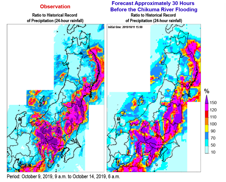
Prediction of the ratio to historical record of precipitation during Typhoon No. 19 in 2019 (Figure 1)
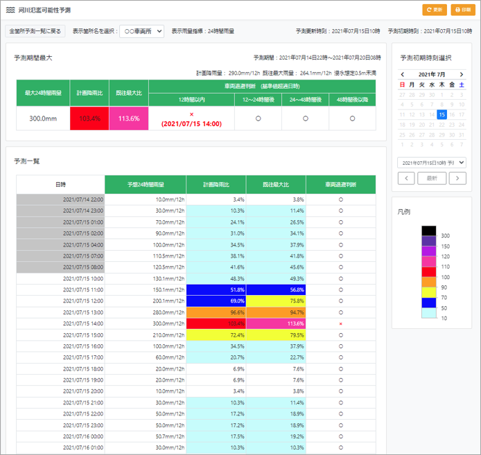
Display Image of Railcar Evacuation Decision Support Information (Table) (Figure 2)
Contact an expert for this service.

Services & Solutions Services & Solutions
-
Electric Power Demand Forecast
-

Solar Power Generation
-

Wind Power Generation
-

Environmental Impact Assessments
-

Disaster Mitigation・Crisis Management・Climate Change Measurements
-

Transport (Roads, Rails, Air, Oceans)
-
Meteorological and Oceanographic Forecasts & Real-Time Data Provisioning
-

Manufacturing, Retail, Advertising, and Marketing
-

tenki.jp & Media Services
-

Web, Apps and Other Services