- Home
- Services & Solutions
- Disaster Mitigation・Crisis Management・Climate Change Measurements
- Landslide Prediction System
Services & Solutions
Landslide Prediction System
Supports early detection of imminent abnormalities in facilities due to landslides, optimizes patrol areas and efficiency, and ensures the safety of patrol personnel.
We provide the system that calculates the comprehensive landslide risk levels based on the customer’s specific use case. The calculation is based on past cases of landslide incidents near the customer’s facility and considers a combination of three major factors that indicate landslide probability:
the slope risk index (the amount of water accumulated in the soil); the snake line pattern (rainfall patterns observed in the past landslides cases); and topographic factors (terrain conditions such as degree of undulation and slope inclination).
This system provides landslide risk assessment by incorporating rainfall data on a 1 km grid, in addition to conventional AMeDAS data. It calculates and displays comprehensive landslide risk levels on a 1 km grid, allowing users to assess risks up to six hours in advance.
Features
- Visualized comprehensive landslide risk levels
The system displays landslide risk levels on a map interface. Effective for largescale and linear facility networks; Particularly useful for assessing landslide risks in extensive facility networks and linear infrastructure networks in mountainous areas (e.g., power transmission line networks, pipeline networks, rail line networks, road networks, etc.).
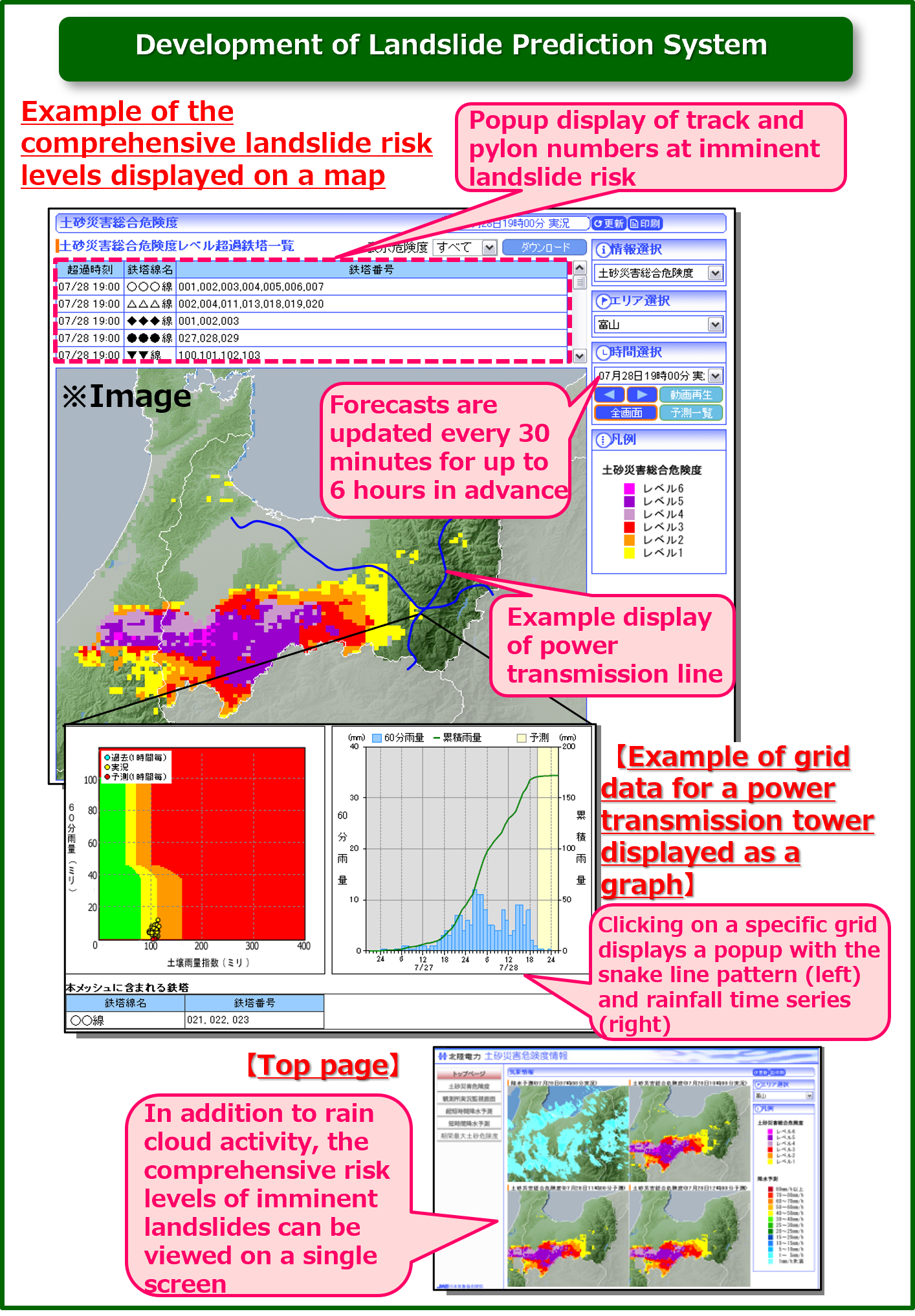
Example of how this system is used in a power transmission line network owned by an electric power company
Applications
- Early detection of facility abnormalities
- Optimizing patrol coverage and efficiency
- Ensuring patrol personnel safety
Contact an expert for this service.

Services & Solutions Services & Solutions
-
Electric Power Demand Forecast
-

Solar Power Generation
-
Wind Power Generation
-

Environmental Impact Assessments
-

Disaster Mitigation・Crisis Management・Climate Change Measurements
-

Transport (Roads, Rails, Air, Oceans)
-
Meteorological and Oceanographic Forecasts & Real-Time Data Provisioning
-

Manufacturing, Retail, Advertising, and Marketing
-

tenki.jp & Media Services
-
Web, Apps and Other Services